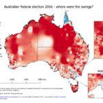
Mapping anything to do with Australian federal elections is a problem because of the disparity in electorate sizes. Some individual electorates are larger than some whole states. I made this map a while ago, to show the swings (on a two-party preferred basis) in the 2016 federal election. This was the election where the Liberal/National […]
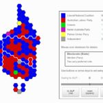
A hexagon cartogram for the Australian 2016 election
Hexagon cartograms are often used for UK election results, but I haven’t seen them much in Australia. I wanted to try creating one. And I’ve added swing controls so you can model a swing to the ALP or the Coalition and watch the seats change hands. Mouse over electorate for details: Electorate (State) Member (Party) […]

